Interview: Jeff's Map Creator Jeffrey McMurtrie


Jeffrey McMurtrie lives in Toronto and first visited Algonquin when he was eight. He fell in love with it and ever since then, he has been back numerous times (and spent over 500 days) to create his own highly detailed map of the park. We sat down with Jeffrey to find out more about his map which he has been working on since August 2006...
Traversing: Do you have a lot of Canoeing buddies here in Toronto?
Jeffrey: Now, yes. Most of them are people I've met online, mainly through Algonquin Adventures). Over the years, through different gatherings, I've probably met well over 50 people that way. Some, I only see at the gatherings and some I do more regular trips with. For the last two years I have done the Algonquin Outfitters Meanest Link route entirely with people I have met through the Algonquin Adventures website.
Traversing: So has the internet been the best way to connect with people?
Jeffrey: Absolutely. I started going to Algonquin with my Dad, and then with another friend. If it wasn't for online, it would probably still only be with them.
Traversing: So how has it been camping with "strangers".
Jeffrey: To date it has been great. It's the same experience as meeting someone on a portage and stop to chat.

Traversing: Take me back to the beginning of Jeff's Map. What got you started?
Jeffrey: I was canoeing with a friend, and it was his first canoe trip. We decided to go to the area West of Canoe Lake which is all low maintenance. There was a few portages that were missing and one lake with the wrong number of bays on it (which was a fun little detour). Over the years I kept telling the MNR about the mistakes, but nothing was ever done about it. There is this old .PDF online from the Friends of Algonquin, and if you look at the details of it on your computer, you can see that it was made in Adobe Illustrator. So I downloaded the Adobe Illustrator trial and started playing around and editing the original map... followed by another edit... and another... until I had actually removed everything from the original file. I had been working on my map for about two years, eventually re-doing it from scratch and then posting it online. It was never intended to be a 'big thing', but rather only for my own use.
Traversing: How hard was it to get the maps into stores?
Jeffrey: I already knew someone that made a map, so thankfully he told me the places to use and get started with. It was great to skip steps where he had problems. There were already stores interested in selling my map (Algonquin Outfitters and The Mad Musher) so to expand I went to other stores and showed them in person. I sent mail-outs to places in Waterloo, Ottawa and Toronto.

1 : 80,000, waterproof, tear resistant and only $15 each
Traversing: How hard was it to implement waterproofing?
Jeffrey: I started making print copies with the second version of the map, because originally I didn't want to deal with all the hassle. People started requesting the printed version because they wanted to use it on trips. Originally it was a paper book version with a paper spine. The tail end of version two, and all of version three was spiral bound along with a waterproof edition. The costs were much higher to do spiral bound versus an actual map, so the format changed for the current version.
Traversing: Did you have any prior experience with Adobe Illustrator?
Jeffrey: I think now I know about 90-95% of the program, but it has all been from learning it to create the map. Lots of times I do things the hard way but realize later on that there is a much easier way. Take for example version three of the map. It was created from all the things I learned how to 'not do the wrong way'.
Traversing: How big is the map file itself?
Jeffrey: It is about 140 layers, 17 million points and 250MB in size. Just to open it up takes a bit of time.
Traversing: So this has definitely been a labour of love for you?
Jeffrey: Absolutely! I wouldn't want to guess how many hours I have put in to it. Back when I was in school, I would come home after classes, work on the map until early morning. I was probably spending more time on the map than school. Now that I'm out of school, if I'm not going out I'll be working on it all day.
Traversing: Are you nearing a completion point?
Jeffrey: It's certainly closer to being done than it was before. Things change over time, and that's the majority that I work on. There are also things that I would consider corrections that aren't factual corrections, such as the colours. They are a big deal in terms of readability. This version is a big improvement over the previous one and I'm always trying to improve that. I think I spent over three months on the colours alone and still feel that certain things could be just a little bit darker or a little bit lighter. I could spend an hour changing the 'blueness' of something. In my mind, when I send it to the printers, it is perfect. From then on, it gets worse and worse because people find more and more mistakes and that's fine. It is a never ending task to make it "perfect".
Traversing: Do you get a lot of feedback?
Jeffrey: Oh yeah! That's a really, really important part of the map. I probably get thousands of e-mails from canoeists which plays a huge role. It's physically impossible for me to go everywhere, and even if I have been there, I haven't been in many years. Probably the most important thing in making the map subjectively good as it is, is from all of the contributions.

Traversing: Are there any interesting design elements that went into the map?
Jeffrey: The process you go through to plan your trip means that you're probably going to choose your access point first. That's why they are all big black squares that you can see from three feet away, where as the little details such as the fishing icons blend into the background. The concept is that you should be able to have the map in the bottom of a canoe and be able to just glance at it and see all the really important things such as the camp sites and portages.
Traversing: Did you go to school for any of this?
Jeffrey: I first went to York for something totally unrelated, and then they cancelled my program. People were suggesting that I do more of this type of work so I switched to University of Toronto and Majored in Environmental Geography and Minored in Human Geography and G.I.S.
Traversing: Did you break the original map into chunks?
Jeffrey: No, it's one big thing. Massive!
Traversing: How much do you think you've covered?
Jeffrey: I've probably done 60 to 70% which also means that there are places I have covered many, many times and some I've only traveled once. Certain routes are more direct and faster and if you want to see new things, you usually take the 'express route' back. I've probably only been to the East side three times.
Traversing: What's your favourite spot so far?
Jeffrey: That's difficult. Generally any place that's really remote. It's nice to get an experience where you can feel like you're in the middle of nowhere.

Traversing: Plans to tackle more of Algonquin Park?
Jeffrey: Always! Every trip you want to incorporate something new. In some ways there is a good thing about not seeing everything because there is always something new to see. It was neat to do the Meanest Link trip because it takes you across Highway 60, which I've never done before because normally it is too busy. It was nice to do it in a sense just once because it was a day where everything was entirely new.
Traversing: Any favourite gear?
Jeffrey: I got a lot of new gear recently, and my favourite is a gravity filter. Before, I used to be the one who pumped all the water with a Katadyn filter. I've had it for about 10 years, and it worked really well except that when it got clogged and you started pumping, water would spray out the top. I would actually wear a bathing suit when getting water at night because I would get absolutely soaked. Depending on the season, it gets really cold, so the gravity filter is really great because I no longer have to get soaked.
Jeffrey will be speaking at the upcoming 2nd Annual Kitchener Waterloo Canoeing Symposium, so make sure to purchase a ticket to hear him speak.
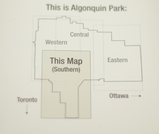
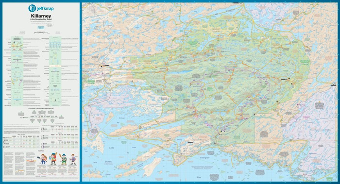
Jeff's Map: Algonquin For Canoeists comes in four different 85g maps (Western, Central, Eastern and Southern). You can download the maps for your computer, iOS device, Garmin GPS or use it with Google Earth. Check out your local outdoors shop for Jeff's Map or purchase them through his website ($15 each or deals if you buy them in bundles).