Guest Blogger: Dean Campbell's Trip Report of Hiking at Lion's Head

Dave Pauls and I early on day one
Hiking at Lion’s Head Over the weekend, a good friend and I went on a simple overnight hike on the Bruce Trail, through the Lion’s Head Provincial Nature Reserve. Our schedule was tame - about 8km each day - but we wanted to focus on taking time to enjoy the trip. Neither of us had done much overnight backpacking in a while, and while we’ve got long histories of being active, neither of us were certain how we’d do with packs on our backs.

Dave Pauls on a side trail heading to the main trail
The Lion’s Head preserve is located on a square-shaped peninsula that juts from the side of the far larger Bruce Peninsula, into Georgian Bay. It sits directly adjacent to the village of Lion’s Head, Ontario, and both get their name from the rather dramatic rock outcropping called - of course - Lion’s Head.

This marker was just in from the trail head.
We opted to park at the trailhead at the end of Evergreen Road, just north of Barrow Bay. A side trail from the Bruce leads from the end of the dead end road into the preserve before splitting in a couple of directions.
We took the right fork, leading to the Bruce Trail along the south side of the peninsula.

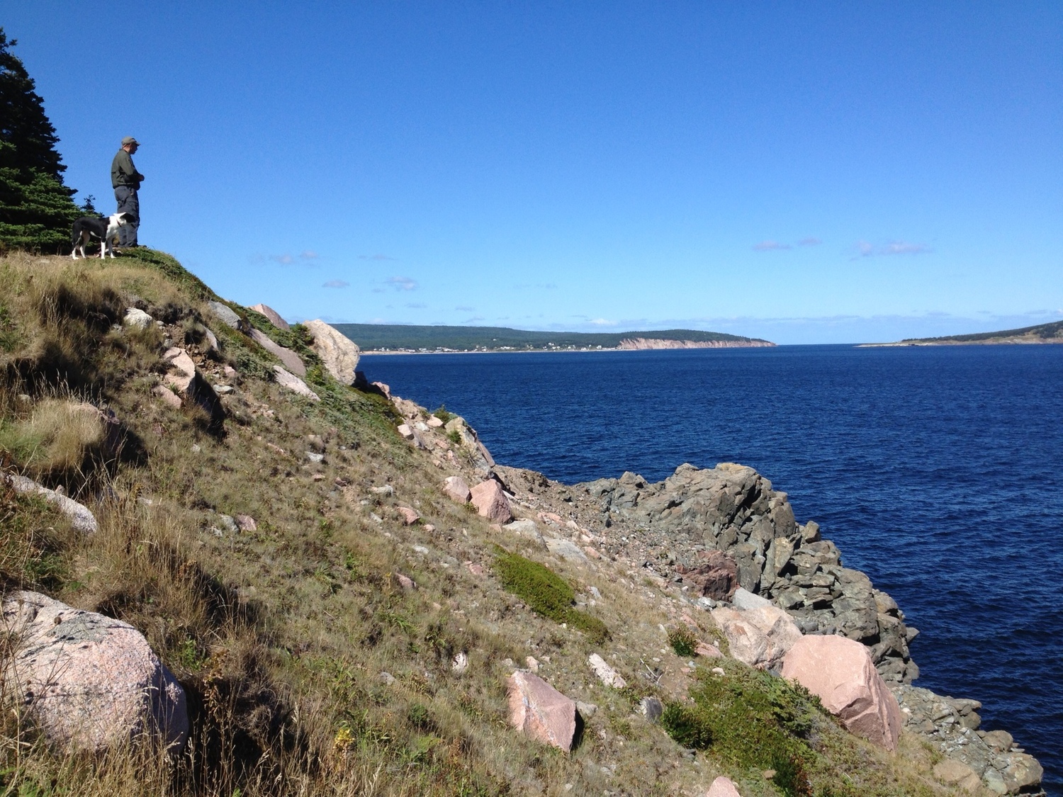
Dave Pauls looks out to the southeast over Georgian Bay
Starting a little after 9am, we made descent time along the side trail before reaching the cliff edge and the Bruce Trail proper. Turning northeast, we started following the white blazes along the edge of the cliff, with plenty of great views to our right.

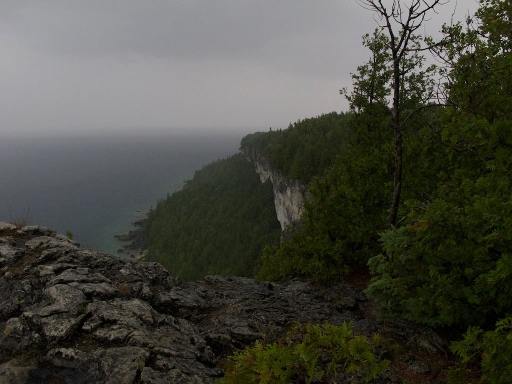
Cliffs and water characterize much of the trail through here
The trail itself is well defined, so following the blazes was more of a formality than a navigational necessity. That said, it’s worth noting that the trail offers up some challenge in the form of tricky rock sections, and roots that in the rain would be very treacherous.

Dave Pauls flakes out
We enjoyed the sunny skies and mild temperatures and stopped for a lunch of ham and camembert sandwiches in front of a spectacular view of Georgian Bay.

The colour of the water in the area never ceases to amaze me
Rounding Gun Point, we saw the incredible aqua blue waters that run like a ribbon along the shore of the east side of the Bruce Peninsula. The colour makes the water look warm and inviting, but this area was frozen solid enough to walk on just six months prior.

Dave Pauls became an Attenborough a few times along the trail. In this case, he pointed out some small orchids.
Wildlife along the way proved mostly shy. We saw a couple of garter snakes, and plenty of interesting flora, including ghost mushrooms, plenty of ferns and a few orchids. Brush up on your identification skills for poison ivy to avoid brushing up on the plant itself. There was a lot of the three leafed plant trailside.

Amazing looking water. the small bay or inlet before the first point is McKay's Harbour, our campsite for the night.
The final half hour of the first day involved a snaking descent that dropped down to the water’s edge at McKay’s Harbour, an overnight rest spot on the Bruce Trail. McKay’s Harbour is little more than a small intrusion of water into an otherwise straight north east face of escarpment. Fronted by a rock strewn beach, the campsites sit back under cover of conifers, with room for a handful of tents. Booking ahead isn’t required, and large groups are discouraged from using the spot in an effort to ensure there are spots for solo hikers. Though we opted for a tent, there are plenty of trees well located to hang out in a hammock.

At camp, getting organized for dinner time.
Campfires are not allowed at McKay’s Harbour, so we made dinner and breakfast on a camp stove. We pulled water from Georgian Bay, and treated it with water purification tabs, or boiled it. A short, cold swim was a great contrast to the heat generated by packing in our gear.

Not long after it started raining, we found this amazing ledge under which to rest. We joked about staying there until the rain stopped. We didn't. The rain didn't stop.
When morning rolled around, a look skyward revealed that the blue vistas from yesterday were long gone. Instead, a mix of greys had rolled in overnight. While boiling water for coffee and breakfast, a few tentative drops began to fall, and the clouds began to darken. We hustled to get packed up and back on the trail.

Dave Pauls and I partway through day two. Dave's smile isn't as big now.
From McKay’s Harbour, there’s only one way to go. Up. Working our way back up the escarpment, our pace slowed as the skies began to drizzle, then rain. We stopped for a snack partway up underneath a massive rock ledge. We discussed waiting out the rain, but the storm seemed to build, not fade. We pressed on. By the time we reached the top of the cliff, we were full aware of just how slippery wet limestone and tree roots can be. My friend had picked up a walking stick which I borrowed in the trickiest sections. By the time we reached the Lion’s Head lookout, the rain was coming down so hard that we only looked out briefly - into a wall of grey - before continuing along the trail.

The rain began coming down harder, and the skies got much darker.
We heard thunderclaps, though wherever the lightning had struck, we never saw it. The stretch of the Bruce Trail heading northbound from Lion’s Head was some of the hardest trail we’d see all weekend. There was plenty of elevation change and slippery rock. In the dry, it would have been tiring, but the rain added an extra challenge.

The last photo I took before putting the camera away in a drier location. Just after this, we started to hear thunder.
Upon arriving at one of two trailside potholes, we picked up a side trail that led back across the preserve towards where we had parked. In better weather, the plan would have seen us add another 3km of trail to extend the loop. Soaked from head to toe despite proper rain gear and waterproofed boots, with no sign of the rain stopping, we opted for the quicker way back.
The side trail was also much easier to negotiate. A mix of double track and single track trail snaked through a forest of tall deciduous trees that seemed to pop in bright greens as the sun tried to break through the clouds. The final stretch of trail was a mix of forest and tall grass fields.
Arriving at the car, we both changed into the only dry clothes we had - long underwear in case the cool summer night pushed into colder temperatures - and hopped into the car, our gear fully soaked through and strewn all over the back of the car.
The distance of the hike and the views made it a simple hike to get back into the swing of things. We both came out a little sore in all the places that hiking is so capable of identifying. But we also recognized that in good weather, this would make an excellent first-time backpacking experience. Weather is unpredictable on the Bruce, so being prepared with the right clothing is important, as is a good attitude.
Maps of the entire Bruce Trail can be had at brucetrail.org. Our trip started at the Cemetery Road Access Trail on Map 38. The 26th edition of the Bruce Trail guidebook shows the side trail connecting with the Bruce at 70.5km, and McKay’s Harbour camp at 77.1km. We left the main trail at 80.3km and used the Ilse Hanel side trail to get back to the trailhead.
You can connect with Dean on Twitter.